8.4.2 How to read a Synoptic Chart

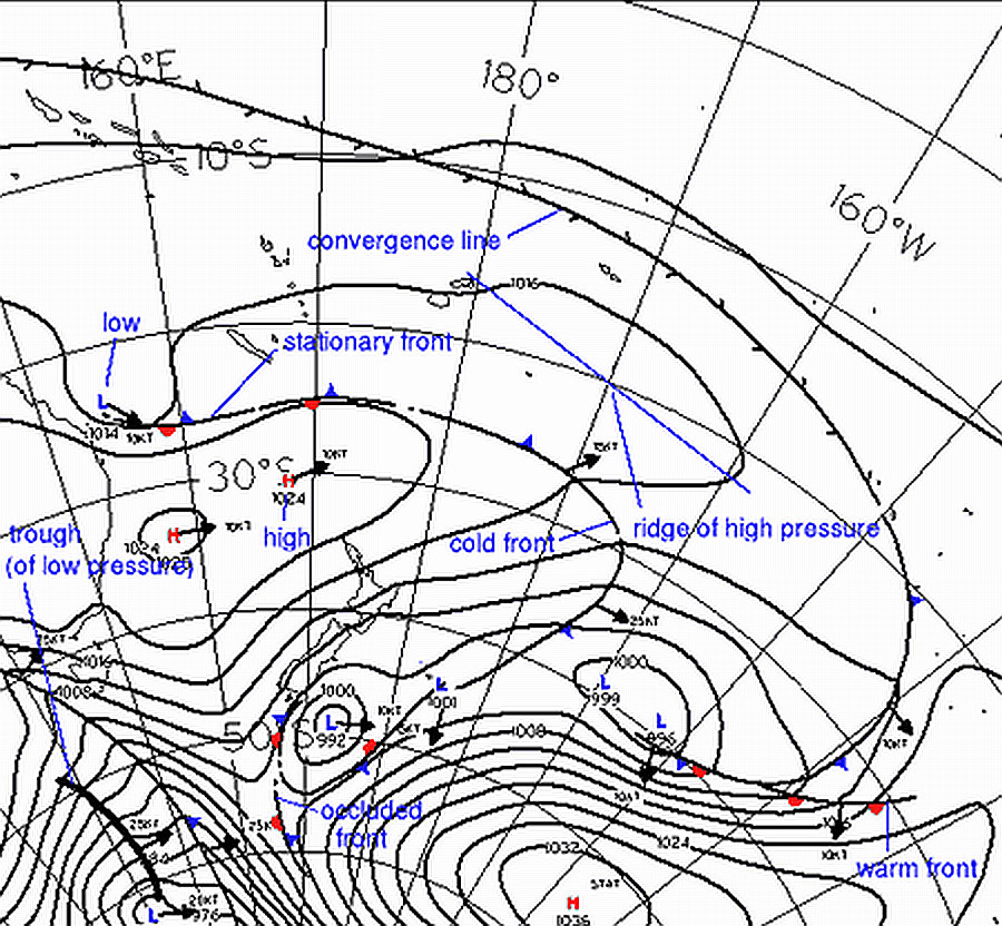
  • Isobars – lines of equal pressure marked as lines around highs and lows. The closer the isobars, the stronger the winds
  • Anticyclone (“high”) – Shown as an “H
  • depression (“low” or “cyclone”) – Shown as an “L
  • Ridge of high pressure – When isobars turn a sharp corner around a High they form what is called a ridge of high pressure, which is often shaped like a tongue extending from the High center.
  • Trough of low pressure – Black lines showing unstable air
  • Col – A Col is the neutral area between highs and lows. Shown as a large gap in isobars
  • Cold fronts – marked by a line with triangles pointing to where it is moving
  • Warm fronts –  marked by a line with semicircles pointing to where it is moving
  • Warm Sector – The area behind a warm front and ahead of a cold front
  • Occluded fronts – marked by a line with triangles and semicircles on the same side
  • Stationary fronts – marked by a line with alternate triangles and semicircles on opposite sides

8.4.2 Identify the following features found on surface weather maps:
8.4.8 Identify areas of light, moderate and strong winds on a weather map.

8.14.2 Katabatic winds

  • High altitude air cools and becomes dense
  • Dense air is flows down mountain slopes
  • In New Zealand Katabatic winds are little Winds
8.14.4 Describe the development of katabatic winds with reference to:
(a) timing of the occurrence;
(b) average strength of katabatic winds over New Zealand

8.30 How a thunderstorm is formed

Three conditions are required for the development of thunderstorms:

  • Rising Air
  • Moisture
  • Unstable Air

8.30.2 State the three conditions required for the development of thunderstorms.

8.24 Precipitation

Related Syllabus Items

8.24.2 Define: (a) precipitation; (b) virga.

8.24.4 Describe the following types of precipitation: (a) rain; (b) drizzle; (c) snow; (d) sleet; (e) hail.

8.24.6 State the difference between large drizzle and small rain droplets.

8.24.8 Describe the following terms in relation to precipitation: (a) continuous rain; (b) intermittent rain; (c) showers.

8.24.10 Define the following precipitation rates: (a) light; (b) moderate; (c) heavy.

8.32.12 Flying around Thunderstorms

Three stages in the life-cycle of a thunderstorm:

  • Cumulus/ Growing Stage – Strong updrafts, often suspending all water or ice
  • Mature Stage – Heavy water and Ice overcome updrafts and fall at a great rate.
  • Decaying Stage – Updraft cease, only downdrafts remaining at great speeds and usually great participation

Hazards associated with thunderstorms:

  • Cumulus/ Growing Stage – Light Aircraft can be forced upwards by the updrafts.
  • Mature Stage – Falling water, ice and air mix with updrafts causing severe turbulence. Squalls and Wind shear. Low visibility. Lightning
  • Decaying Stage – Squalls, severe turbulence, Wind shear and loss of altitude due to downdrafts
8.30.4 Describe the three stages in the life-cycle of a thunderstorm.
8.30.6 List the hazards associated with thunderstorms.

8.28.12 SLEET SNOW AND FREEZING RAIN EXPLAINED

Drizzle – Fine and close together droplets. Droplets can be suspended due to small size causing bad visibility.
Snow – Ice crystals. Remains frozen
Sleet – Frozen Precipitation that melts passing through a warm layer of air and refreezes before reaching the surface
Hail – Ball like pieces of ice caused by intense up and downdrafts in Thunderstorms

8.24.4 Describe the following types of precipitation:
(a) rain;
(b) drizzle;
(c) snow;
(d) sleet;
(e) hail;

8.28.4 How Does Frost Form?

  • Ice is formed through deposition (Gas directly to Solid).
  • Cold moist air will form into hoar frost when passing over a very cold surface i.e our aircraft skin.
  • Happens on the ground in very cold conditions, or in air above the freezing level.
8.28.4  Explain the processes involved in the formation of hoar frost on an aircraft on the ground and in flight.

8.28.14 Carburettor Icing

  • Most common in cool summer or early fall days when there is high moisture
  • Can happen at warm temperatures as Venturi effect in the carburetor lowers the temperature of air dramatically
  • Carb heat is best used often as a prevention method rather than for de-icing
8.28.14 Explain the environmental factors involved in carburettor icing, including;
(a) moisture content;
(b) temperature;
(c) temperature gradient (inversions).

8.36 Cold Fronts and Warm Fronts

  • A front marks the boundary between two air-masses, and appears on the weather map as a line with triangles or semicircles attached.
  • Cold – Cold fronts push in underneath the warmer air ahead of them,  forcing the warm air upwards and making cloud and areas of rain.
  • Warm – advancing warm air rises over a zone of retreating cooler air, making a cloud bank that slopes forwards from ground level upwards, often bringing prolonged steady rain.
  • Occluded – a cold front overtakes a warm front, so that all that remains of the original warm air is trapped above, where it cools making dense cloud and rain.
  • Stationary – a  front is one which has lost its movement. Any rain clears slowly and temperature and pressure do not change much.
8.36.6 Define a ‘front’.
8.36.8 Describe the formation processes of the following frontal types:
(a) cold
(b) warm
(c) occluded
(d) stationary

8.26 Visibility and Fog

Clouds that touch the ground are fog.

Warm Moist air moving over a cold surface can create fog.

8.26 Visibility and Fog